
KABC-TV chief meteorologist Dallas Raines has been at ABC’s flagship Los Angeles station since 1984, so you’d think he’s seen everything he could ever see when it comes to Southern California weather. But Hurricane Hilary is a first, even for him, and he’s ready for it.
“It’s really a crazy situation,” he tells Variety. “This is my 40th year of forecasting weather in Southern California, and there have been many opportunities for tropical cyclones that have come up out of Mexico. I would go year after year during hurricane season, ‘Maybe this is the year that conditions are gonna be perfect to bring something up into Southern California.’ Every year, it would be no. You need a perfect situation for these cyclones to actually come up on that trajectory and hold together once they encounter the cold water that’s off the California coastline. It’s about a once-in-a-century event.”
But this is that year. For the first time since 1939, when a tropical cyclone hit Long Beach, a hurricane is on pace toward Southern California. By the time it comes here, it will likely be a tropical storm. But Raines warns that it could still pack a wallop.
“I’m more concerned about the flooding situation,” he said. “Because in the 1939 storm, there was a lot of flooding in the desert. There were a lot of roads and bridges washed out. And of course the population has tremendously increased across Southern California since then… Even in the L.A. basin, in the 1939 storm, we had five inches of rain in downtown Los Angeles in a 24-hour period. So it just shows you the potential there even for the L.A. basin to see some flooding, some flash flooding, we could see that happening. And then many of the roads in the mountain areas could be impassable by early Monday morning. You could see flooding out in the desert areas.”
Wind will also still be a problem: Raines is expecting gusts similar to Santa Ana winds, east and northeast winds leading through those canyon passes. For wildfire concerns, the rain that comes with the storm will likely prevent serious problems. But there’s still the possibility that heavy winds will come before the rainfall arrives, still making for a dangerous situation with the dry brush in the canyons, hills and mountains. “There is a chance that you could see wind through those canyons up to 30, 40 and even 50 miles per hour,” Raines said. “And of course, if a fire were started, it could be explosive, even though we have moisture.”
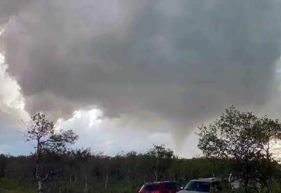
The only thing nearly as unusual as hurricanes in Southern California are tornadoes (although those do pop up here every once in a while). In the case of this storm, Raines said there’s also the possibility of isolated, small F1 tornadoes.
“In these feeder bands that wrap around the tropical cyclone, small twisters can drop out,” he said. “It happens on the east coast all the time. They’re not the F4s and F5s like you see in Kansas and Oklahoma. But they’re moving very quickly. They’re usually going about 50 or 60 knots. They touch down briefly and they can create quite a bit of damage. So a tornado threat is going to be there.”
Raines said he wouldn’t be surprised to see a tornado watch issued for the area alongside a tropical storm watch, which he said for the region is “remarkable.”
Additionally, keep an eye out for the surf. “The storm right now is generating big swells,” he said. “It has 40-to-45-foot swells in and around the center of this 130 mile-an-hour storm. And those swells will be arriving starting tomorrow afternoon and continue all the way into Sunday, into Monday. This would be a south-facing situation. Areas in Orange County like Huntington Beach, for instance. We could be looking anywhere from five to 10 foot breakers coming in from the south. Maybe a little higher, not out of the question. But definitely that’s going to be a big deal.”
Raines warned that people going to the beach and getting into the water would be in danger of serious rip currents. “I would imagine that along the L.A. beaches and Orange County beaches, they’re going to more than likely try to keep people out of the water,” he said. “I don’t know if they can keep the surfers out but it would definitely be a danger for the average person. These rip currents are much more powerful during hurricanes than they are in the storms that we might have during the wintertime.”
As for how KABC/ABC7’s “Eyewitness News” team is preparing for the storm, assistant news director Dan Rasmussen said they’re in a bit of uncharted territory. “I’ve been here for for 10 years and I think of all of the large events that we cover the breaking news: Earthquakes, fires and mudslides and big storms over the winter. But the thing that we always talk about is we never get the hurricanes, like people on the East Coast,” he said. “So it is it is a different approach for us to ramp up for that. We have the muscle memory, we’re used to covering big stories and breaking news. But it’s like, OK, this is different. Where do we need to be, what resources do we need to provide, how do we make sure we’re serving people leading up to it?”
It’s also hard to plan, he added, because at the moment Los Angeles is experiencing a clear, blue sky day. “I mean, I look out my window right now. It’s beautiful,” Rasmussen said. “My son’s got soccer games both days this weekend. And it’s hard to think that, by Sunday, it’s going to change. Because we’re not we’re not used to that. It’s about maximizing our people, spreading out our resources, obviously, it’s going to last for a while so it’s the coverage on Sunday night, Monday morning, into the day Monday. Preparing people for this.”
Rasmussen said Raines will also be at the center of this weekend’s coverage. The weekday weather anchor will be at the station on Sunday, and KABC is adding an extra newscast at 6:30 p.m. that night (which will also be simulcast on KGO San Francisco and KFSN San Diego, both also ABC-owned stations) to focus on the storm.
“We’ve been doing a live blog, live update, and a live stream of the storm track online since yesterday afternoon,” he added. “There’s a lot going on. We’re teaming up with ABC News and AccuWeather and UCLA to get expertise and additional resources.”
Raines reports that via a reconnaissance aircraft that has been sent into the northern edge of Hurricane Hilary, it currently rates at 130 miles per hour sustained winds, which is on the low end of a Category 4. “Looking at the very latest couple of images, it looks like it’s already starting to weaken because it’s entering cold water,” he said. “And another thing that destroys or is very destructive to tropical cyclones is what we call wind shear. When you get winds that are in the mid troposphere, say about 20,000 feet that come in from the west, they bring in dry air, and tropical cyclones don’t like that. All that being said, this storm is going to come up into Southern California, and with it, it will bring a moisture field associated with it that is tremendous.”
Hence the concerns about flooding, especially in the deserts and mountains. “I think probably for Southern California, the main issues will be people who might go to the beach and then people who may think that they can drive in situations like this,” he said. “Those are probably the type of people that usually get in trouble most and the fact is, we have about 20 million people here. And very few of them have gone through hurricanes or tropical storms. The average person, if they’re not out on the road and putting themselves in a difficult situation or a dangerous situation, they’re going to be OK.”
But for Dallas Raines, this is his moment. Actually, the wild weather that now seems to be the norm in this era of climate change has definitely made his job in Southern California busier.
Raines remembers leaving CNN in Atlanta 40 years ago, and his friends there warning him that he was going to miss all of that region’s dramatic weather. “The last few years I’ve called them and said, ‘no, we got it,’” he said. “Don’t worry. We’ve got all kinds of weather.”