
After the powerful storm once known as Hurricane Lee traveled 3,000 miles across the Atlantic toward New England and Canada, where it made landfall on Saturday, the storm’s remnants have one more journey to make: to the coasts of Britain and Ireland.
The storm system will help usher in traditional autumn weather across Britain this week with cool, wind-swept rains on Tuesday and Wednesday.
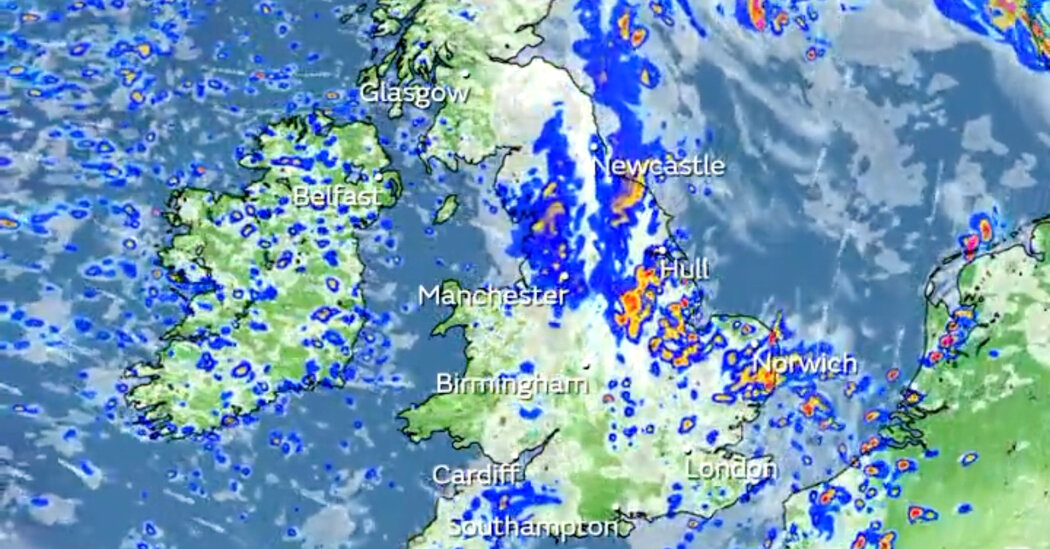
The rains will be heaviest and most persistent across parts of Wales and northwest England, according to the Met Office, Britain’s national weather service. Some flooding is possible in those areas.
The rain is going to fall in areas that are used to wet weather, Alex Deakin, a Met Office meteorologist, said, but because tropical air is mixed into this storm, it will be more moist than usual. “It’s more laden, and so it’s more rain than you get in a usual low-pressure system,” he said.
Mr. Deakin said the storm was following an “unheard-of” heat spell in Britain, where temperatures were above 86 degrees Fahrenheit, or 30 degrees Celsius, for seven consecutive days ending on Sept. 10. “Off the back of that, it’s been quite a switch,” he said.
It’s not unusual for a storm to cross the Atlantic.
The Atlantic-dominated weather pattern is not unheard-of across Britain and Ireland.
In October 2017, the remnants of Hurricane Ophelia bore down on Britain and Ireland, where three people were killed by falling trees.
An October 1987 weather event known as the “Great Storm” brought hurricane-force winds to parts of Britain, with some gusts reaching 100 miles per hour. Eighteen people were killed in the storm, according to the Met Office. Thousands of homes were left without power for more than 24 hours and about 15 million trees were felled.
In the mid-latitudes, storm systems typically move east in an area known as the westerlies. A hurricane will form in the tropics, where the water is warm enough to give energy to a tropical system and where the steering currents are predominantly toward the west. When a hurricane turns toward the north, it will inevitably get caught up in the westerlies. This means it will head east toward Europe.
However, when a storm such as Lee moves over the colder waters of the North Atlantic, it no longer has the fuel it needs from the ocean. For the storm to maintain strength, it has to transition into a typical weather system, which gets its energy from cold air masses and warm air masses colliding. Sometimes, these storms are strong enough to support hurricane-force winds, as Lee did as it made landfall in Canada this past weekend. The storm has since weakened and as it leaves Canada behind on Monday, it will make haste, approaching Ireland and Britain on Tuesday.
Lee isn’t the only storm that could have a prevailing effect on the weather across Ireland and Britain this week. Hurricane Nigel, which is in the Central Atlantic, appears to have a track that will bring it close later in the week.
Mr. Deakin of the Met Office said that Nigel was “still quite lively and potentially going to bring us another wet, windy spell at the weekend.”