

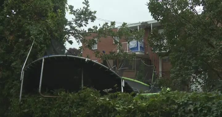
A severe weekend storm in Quebec had drivers dodging debris and a weather agency investigating whether a tornado may have touched down.
The storm hit the Repentigny region, northeast of Montreal, on Sunday.
“There seems to be weak rotation that is typical, not every time we see rotation do we have a tornado,” said Kate LeClerc, meteorologist with Environment Canada.
The Northern Tornadoes Project, based in London, Ont., which investigates potential tornadoes in partnership with Environment Canada, is already on the ground to determine whether the storm formed such a cyclonic system.
Weather radar from Environment Canada shows that during the height of Sunday’s storm, only heavy rain was being tracked in the area. With strong winds not being spotted, no special warning was issued.

Get breaking National news
Get breaking Canada news delivered to your inbox as it happens so you won’t miss a trending story.
“We did have a severe thunderstorm watch in effect in the morning,” LeClerc said. “We forecasted a potential, but in the moment we did not forecast that it was going to be that severe. Only after did we see it was a severe thunderstorm.”
It’s not the first time this summer that Quebec has seen tornadoes, with two having touched down on July 21 in the province’s south.
The Northern Tornadoes Project confirmed the first tornado was an EF1 — short for a rating of one on the Enhanced Fujita scale, with winds between 135 and 175 kilometres per hour — in Harrington, Que., northwest of Montreal. A second tornado also spawned in Saint-Donat, Que., at an EF0, with winds between 90 and 130 km/h.
With wide-ranging temperatures, LeClerc said it’s created ideal conditions for the storms.
“One of the key factors has been hot and humid — those two key elements that have been present on and off this (week) will be another week as well,” she said.
Several parts of Quebec’s southern and eastern regions, including the Quebec City area, are under yellow alert rainfall warnings and yellow alert severe thunderstorm watches.
The alerts by Environment Canada warn of various amounts of rainfall. Some regions like Fermont and Saint Felicien-Roberval could see anywhere from 40 to up to 80 millimetres of rain, with some areas reaching 100 mm. Other communities like Mont-Tremblant-Sainte-Agathe could see lower amounts of 15 mm.
Those under severe thunderstorm watches are being cautioned that such storms are possible and could produce heavy rain, strong wind gusts, hail, and a risk of tornadoes.
—with files from Global News’ Brayden Jagger Haines
© 2026 Global News, a division of Corus Entertainment Inc.